Raster Tile
Important notes:
- This TomTom Orbis API is in public preview.
- This API is powered by TomTom Orbis Maps.
- See the TomTom Orbis Maps documentation for more information.
Purpose
The Maps Raster Tile API endpoint renders map data that is divided into gridded sections called tiles. Tiles are square images in various sizes which are available at 23 different zoom levels, ranging from 0 to 22. For zoom level 0, the entire earth is displayed on one single tile, while at zoom level 22, the world is divided into 244 tiles. See the Zoom Levels and Tile Grid.
Tile layers and styles
The Maps Raster service supports the basic tile layer. It can be served in two different styles: street-light and street-dark.
- The
basicraster tiles contain mapping data such as polygons, road shapes, borders, labels, and road icons.
Tile Sizes
The following tiles sizes are currently supported:
- 256 x 256 pixels: This is better suited for lower resolution displays and clients sensitive to internet data transfer usage.
- 512 x 512 pixels: This is created for displays with high resolutions.
Request data
HTTPS method: GET
For ease of viewing and identification:
- Constants and parameters enclosed in curly brackets
{}must be replaced with their values. - Please see the following Request parameters section with the required and optional parameters tables for these values. The generic URL format is as follows.
URL format
https://{baseURL}/maps/orbis/map-display/tile/{zoom}/{X}/{Y}.{format}?apiVersion=1&key={Your_API_Key}&style={style}&tileSize={tileSize}&view={view}&language={language}
curl command format
curl 'https://{baseURL}/maps/orbis/map-display/tile/{zoom}/{X}/{Y}.{format}?apiVersion=1&key={Your_API_Key}&style={style}&tileSize={tileSize}&view={view}&language={language}'
Request parameters
These parameters are used in calls to generate all tile layers.
- Required parameters must be used or the call will fail.
- Parameters and values are case-sensitive.
- Optional parameters may be used.
| Required parameters | Description |
|---|---|
| The base URL for calling TomTom services.
|
| Zoom level of the tile to be rendered. |
| The x coordinate of the tile on a zoom grid. |
| The y coordinate of the tile on a zoom grid. |
| The format of the response. |
| An API Key valid for the requested service. |
| Optional parameters | Description |
|---|---|
| A version of the API to call. This parameter will overwrite the value stored in the TomTom-Api-Version header if this parameter is set. |
| Style of the tile to be rendered.
|
| The tile size dimension in pixels. |
| A geopolitical view.
|
| The language to be used for labels returned in the response. It should
be one of the supported IETF language code tags described here
or one of the custom language tags. When data in a specified language is
not available for a specific label, the default language is used. |
Request headers
The following table lists HTTP request headers of particular interest to clients of the Maps Raster Tile API endpoint.
| Required headers | Description |
|---|---|
| Contains a version of the API to call. |
| Optional headers | Description |
|---|---|
| Accept-Encoding | Contains the content encoding (usually a compression algorithm) that the client is able to understand. |
| If-None-Match | Contains an identifier for a specific version of resource. The server
will send back the requested resource with a 200 HTTP status code, only
if it doesn't have an ETag matching the given one. |
| Tracking-ID | Specifies an identifier for the request. It can be used to trace a call.
Value: |
Default view mapping
Default view is recognized based on the country the request came from.
| Country | Default view |
|---|---|
| India |
|
| Pakistan |
|
| Argentina |
|
| Bahrain, Kuwait, Oman, Qatar, Saudi Arabia, the United Arab Emirates |
|
| Korea |
|
| Serbia |
|
| Malaysia |
|
| Chile |
|
| Algeria |
|
| Philippines |
|
| Brunei |
|
| Taiwan |
|
| Morocco |
|
| Türkiye |
|
| Israel |
|
| Vietnam |
|
| USA |
|
| Others |
|
Host Name Cycling
Most web browsers have a default limitation on the number of active connections that can be allowed to each host. This means if map tiles are being loaded via the api.tomtom.com host name, they will be loaded one at a time. A trick that can be used to get around this limitation is to cycle through the hosts we have created as aliases. These host names are:
- a.api.tomtom.com
- b.api.tomtom.com
- c.api.tomtom.com
- d.api.tomtom.com
By cycling through these four different host names, the web browser will be tricked into retrieving four map tiles at a time rather than just one. This will significantly speed up the performance of map rendering.
For instance, if four map tiles are being requested at zoom level one, you would request the first one as:
https://a.api.tomtom.com/maps/orbis/map-display/tile/1/0/0.png?apiVersion=1&style=street-light&key={Your_API_Key}
The second would be:
https://b.api.tomtom.com/maps/orbis/map-display/tile/1/0/0.png?apiVersion=1&style=street-light&key={Your_API_Key}
and so on up until d.api.tomtom.com. When more than four tiles are being requested, start back again at a.api.tomtom.com.
Response data
The Maps Raster API, for a single request, returns one square tile in png format.
256 x 256 pixels
| Layer | Main | Night |
|---|---|---|
| basic | 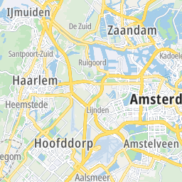 | 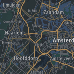 |
512 x 512 pixels
| Layer | Main |
|---|---|
| basic | 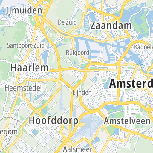 |
Response examples
Example 1
**Whole world at zoom = 0 **
| Request | Response |
|---|---|
Basic street-light zoom = 0: | 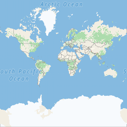 |
Basic street-dark zoom = 0: | 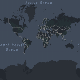 |
Example 2
**Europe at zoom = 4 **
| Request | Response |
|---|---|
Basic street-light zoom = 4: | 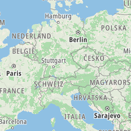 |
Basic street-dark zoom = 4: | 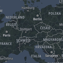 |
Example 3
**Amsterdam at zoom = 17 **
| Request | Response |
|---|---|
Basic street-light zoom = 17: | 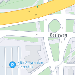 |
Basic street-dark zoom = 17: | 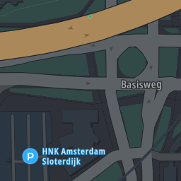 |
Error response
The Map Display API Raster service for an invalid request returns a response body in XML or JSON format. The XML format is returned by default. To have an error response returned in JSON format, application/json has to be specified in the Accept HTTP request header.
Error response field structure
| Field | Description |
|---|---|
| Main object of the error response. |
| One of a server-defined set of error codes. |
| A human-readable description of the error code. |
Error response example
1{2 "detailedError": {3 "code": "BAD_REQUEST",4 "message": "Invalid tile position arguments"5 }6}
1<errorResponse description="Invalid tile position arguments" errorCode="400">2 <detailedError>3 <code>BAD_REQUEST</code>4 <message>Invalid tile position arguments</message>5 </detailedError>6</errorResponse>
Response codes
| Code | Meaning & possible causes |
|---|---|
200 | OK |
304 | Not Modified: The tile has not been modified. This code is
returned when the |
400 | Bad request : Probably malformed syntax.
|
403 | Forbidden : The supplied API Key is not valid for this request. The requested view is not available in the country from where the request was sent. |
429 | Too Many Requests : Too many requests were sent in a given amount of time for the supplied API Key. |
500 | Internal Server Error : There is a problem with the TomTom Maps Raster Tile service. |
503 | Service currently unavailable. |
Response headers
The following table lists HTTP response headers of particular interest to clients of the Map Display API Raster Tile endpoint.
| Header | Description |
|---|---|
| Access-Control-Allow-Origin | The Maps Raster Tile API allows cross-origin resource sharing (CORS). |
| Cache-Control | Contains directives for a caching mechanism. |
| Content-Encoding | Indicates which encodings were applied to the response body. |
| Content-Length | Contains information about the size of the response body. |
| Content-Type | Indicates the media type of the resource returned. |
| Date | Contains the date and time at which the message was originated. |
| ETag | Contains an identifier for a specific version of resource. |
| Expires | Contains the date after which the response is considered outdated. |
| Transfer-Encoding | Specifies the form of encoding used to safely transfer the response to the
user. If this header is specified, the Content-Length header will be absent. |
| Tracking-ID | An identifier for the request. If the Tracking-ID header was specified in
the request, it is replicated in the response. Otherwise, it is generated automatically by the service.
For details check RFC 4122. |