Traffic Flow - Protobuf
Purpose
The TomTom Traffic Flow - Intermediate Service - Protobuf (hereafter called 'Service') is designed for server-to-server integration with traffic control center, routing, navigation, and mapping applications. It contains real-time travel times and speeds for segments, based on TomTom's Traffic technology, with several possible configurations.
This document describes the data exchange method and the payload description of the Service interface. Be aware that the 'Service' is available in three variations:
- TomTom Traffic Flow (Standard feed)
- TomTom Traffic Flow Detailed (higher road coverage) and
- TomTom Traffic Flow Detailed Legacy (higher road coverage, shorter links, no dynamic sectioning)
See more details on differences between Flow and Flow Detailed in the FAQ.
Scope
This document gives basic information on the Service and shows how to configure it to work with your environment. The user is expected to have basic installation knowledge and experience using protocol buffers.
Intended audience
This document is intended to be used by TomTom partners and customers (decision makers and developers).
Features
TomTom offers traffic flow data to customers. A custom product is configured based upon your specific needs. The product is static, so included regions and features are fixed (once the product is configured), it contains standard configuration and also provides customizable configuration options (see section Available features).
Request data
The Service uses RESTful API (Representation State Transfer) technology. Since you only need to use one URL, the Service is relatively uncomplicated to use. To make a request, the URL is constructed as shown in the following sections.
Important
To use this Service, ensure that all prerequisites are met as described in the section A secure connection or at Authentication for client certificate access.
HTTPS Method: GET
For ease of viewing and identification:
- Constants and parameters enclosed in curly brackets { } must be replaced with their values.
- Please see the following Request parameters section with the required and optional parameters tables for their values.
The generic request format is as follows.
The sample URL is formatted in one of two possible ways:
TomTom Traffic Flow
https://{baseURL}/tsq/hdf/{productName}/{apiKey}/content.proto[?flowType={flowType}]
The following is an example URL:
https://cert-traffic.tomtom.com/tsq/hdf/DEU-OPENLR/{Your_API_Key}/content.proto
The following is an example cURL request:
curl --compressed -XGET 'https://cert-traffic.tomtom.com/tsq/hdf/DEU-OPENLR/{Your_API_Key}/content.proto'
TomTom Traffic Flow Detailed / TomTom Traffic Flow Detailed Legacy
https://{baseURL}/tsq/hdf-detailed/{productName}/{apiKey}/content.proto[?flowType={flowType}]
The following is an example URL request:
https://cert-traffic.tomtom.com/tsq/hdf-detailed/DEU-OPENLR/{Your_API_Key}/content.proto
The following is an example cURL request:
curl --compressed -XGET 'https://cert-traffic.tomtom.com/tsq/hdf-detailed/DEU-OPENLR/{Your_API_Key}/content.proto'
Request parameters
The following table provides a detailed explanation of the available fields that were previously shown.
| Required parameters | Description |
|---|---|
| Base URL for calling the API. |
| Name of the product (feed) you are requesting.
These will be indicated to you as part of the
provisioning process. Typically, it explains the
country (country code), and the location referencing
method (see Location referencing). |
| Authorization key for access to the API. |
| Optional parameters | Description |
|---|---|
| When the feed is requested without the parameter
When using this parameter, at the first request the free-flow information should be downloaded. Afterwards, non-free-flow information can be downloaded for each future request. The free-flow and non-free-flow data are related. The segments for both files should be in sync, otherwise there is a mismatch in the locations of the free-flow data. Therefore, every time the non-free-flow information is downloaded, it must be checked. This insures that the non-free-flow data corresponds to the free-flow data (that the user already has). The verification is done by confirming the |
Request headers
Since flow feeds can be very large, TomTom recommends optimizing the information transmission as much as possible. Through optimization, the client receives more up-to-date information.
All responses will be gzip compressed as it significantly reduces the payload size. The use of the HTTP header
Accept-Encodingis required. For more information see our page about Gzip compression.
| Headers | Description |
|---|---|
| If-Modified-Since | TomTom recommends using the standard HTTP header
|
Response data
Response codes
| Response code | Description |
|---|---|
| 200 OK | Indicates that the request has succeeded. The response body will contain the requested data. |
| 304 Not Modified | Only used if the |
| 401 Unauthorized | Indicates that the request requires user authentication information. The client MAY repeat the request with a suitable Authorization header field. |
| 406 Not Acceptable | The server doesn't find any content that conforms with the |
Response example
If you make the following request:
https://cert-traffic.tomtom.com/tsq/hdf-detailed/DEU-OPENLR/{Your_API_Key}/content.proto?flowType=nff
You can expect a response that contains protocol buffers binary data. The textual representation of this data could look like this:
1metaInformation {2 createTimeUTCSeconds: 14520929103 supplierAndClientInfo {4 clientID: "db14af1d-3827-4d61-8525-8f70bc1c5b3f15e87601"5 supplierID: "TomTom Traffic Service"6 }7 }8[...]9trafficFlow {10 location {11 openlr: "\013\t\223\332%UF\033`\013\001)\002$\033S~"12 }13 speed {14 averageSpeedKmph: 515 travelTimeSeconds: 33416 confidence: 9717 relativeSpeed: 0.10618 trafficCondition: STATIONARY_TRAFFIC19 }20}21[...]
Response - Protobuf payload specification (analysis of the received output)
Protocol buffers is the de-facto standard for encoding and transmitting any structured information in a compact, platform-independent way. TomTom uses protocol buffers (version 2) format for the output payload. After defining the data structure an encoder and a decoder can be generated for integration into C++, Java and several other languages. Also see http://code.google.com/p/protobuf or https://protobuf.dev for more information.
Important: Protocol buffers schema
Our output type uses the proprietary TomTom protocol buffers message types. The data structure of the protocol buffers output is defined in the schema file ProtobufTrafficFlow_v8.proto. TomTom supports schema version 8 and above.
All fields are marked as optional, as recommended by Google, but the output always contains flow information (including a location).
The following table contains a brief description of the supported message types used in the data structure. More detailed information about the individual message fields can be found in the following sections: some fields are filled in by default, other fields require a specific feature to be enabled with the product.
| Protocol buffers message type | Description |
|---|---|
TrafficFlowGroup | The traffic flow group is the top-level message.
It provides meta data (see |
MetaInformation | The meta information message provides data shared by all traffic flow messages. |
SupplierAndClientInfo | The supplier and client information message identifies the client and the supplier. |
TrafficFlow | The traffic flow message assigns speed information to a location. It may also identify road blockages. |
TrafficFlowWithPrediction [deprecated] | The traffic flow message assigns current and future speed information to a location at several points in time. It may also identify road blockages. This message type is used with products configured for prediction and NOT for breaking up locations into sections. |
TrafficFlowWithPredictionPerSection | This message assigns current and future speed information to sections of a location at several points in time. |
Speed | The speed message subsumes all speed and travel time related information. Which fields are set depends on the customizable product configurations (see the section Available features). |
SectionSpeed | The |
SpeedWithTimeStamp [deprecated] |
|
SpeedVector |
|
Location referencing
Geographical representation of the road segments is an important part of the payload. There are two geographical representations that are supported: TMC and OpenLR. Since OpenLR prevents interpretation differences, licensing costs, map dependencies, or version dependencies, TomTom recommends using OpenLR instead of TMC. TMC based data is still offered for customers with existing platforms that need compatibility with their legacy systems.
OpenLR
OpenLR is a dynamic location referencing method that allows referencing of any road on the complete digital map. Because of its flexibility, it is possible to describe traffic events on high-level and lower-level road classes that are usually not covered by TMC. The method is available free of charge. The service uses binary format version 3, as described in the OpenLR whitepaper. The whitepaper, software developer kit, and open source reference implementations are available for download from the OpenLR website. TomTom offers support for third parties to implement and test their own implementations.
1location {2 openlr: "\v\254\320.!\367\n\033l\a\000Z\376\223\033\000"3 lengthInMeters: 4254}
Traffic Message Channel (TMC)
When using TMC as a geographical representation, travel times are measured by a TMC link. A TMC link is part of a TMC path. A TMC link is a sequence of road elements that starts at a TMC location, and ends at the next TMC location in the TMC table in the specified direction. You can recognize a TMC link by:
- TMC table (country code, location table number, version).
- Primary TMC location, defining the TMC point location at the end of the TMC link.
- Direction, as defined by the TMC path.
- An optional extent (the default value is 1).
The following examples shows a typical TMC link as used in our Service. The meaning of the information contained in the link is explained below in the section TMC link identifier.
1location {2 tmc: "D01p00015"3}
Generally, the set of TMC link identifiers that can be used in a TrafficFlowGroup is static. That
means that in subsequent snapshots, the same locations are used. However, this is not always the
situation. Sometimes, the set of the TMC link identifiers that are used can be changed. These
changes occur when a new TMC table is introduced.
TMC link identifier
TMC Chain Information is composed of the following parts CVVDLLLLL\[xE\[E\]\]:
| Part | Description |
|---|---|
C | Hexadecimal country code as described in IEC 62106. |
VV | This is the TMC Location Table code. |
D | TMC direction of the chain (defined by the TMC path). For possible values, see TMC direction. |
LLLLL | TMC point location code. If the number is not five digits long, zeros are added at the beginning until there are five digits. |
[xE[E]] | Either empty, when extent = 1, or fixed letter |
Using the specified TMC table, the secondary location (start of the stretch) can be found from the
primary location, the direction, and the extent. C, VV, and LLLLL correspond with the TMC Location
Reference that is a unique identifier for a TMC location.
TMC direction
The possible values for D infer the direction of travel (secondary to primary location) along the
TMC path.
| Value | Direction |
|---|---|
p | Positive |
n | Negative |
TMC examples
In this section, we demonstrate how to resolve TMC link identifiers on the receiver side. Here, we map the definition of each of the fields within the link identifier, and provide guidance on using the extent to find the secondary location.
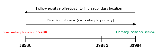
Example 1: 817n39984x2
Given the TMC location data:
- Country code: 8
- Location table number: 17
- Direction from secondary to primary location: negative
- Primary location ID: 39984
- Extent: 2
Interpret the TMC location data to resolve the secondary location:
- Invert direction: negative → positive.
- Since the resolved direction is positive, follow the positive offset path for 39984 in the TMC table for two extents.
- You will find the subsequent positive offsets are 39985 and 39986, therefore, the resolved secondary location is 39986.
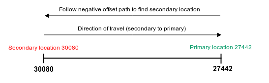
Example 2: D01p27442
Given the TMC location data:
- Country code: D
- Location table number: 1
- Direction from secondary to primary location: positive
- Primary location ID: 27442
- Extent: 1 (if the extent is not provided explicitly, then it is 1)
Interpret the TMC location data to resolve the secondary location:
- Invert direction: positive → negative.
- Since the resolved direction is negative, follow the negative offset path for 27442 in the TMC table for one extent.
- You will find the subsequent negative offset is 30080.
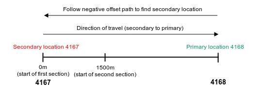
Example 3: TMC location reference with section offsets
1trafficFlowWithPredictionPerSection {2 location {3 tmc: "104p04168"4 length: 37315 }6 speedVector {7 minutesInFuture: 08 sectionSpeed {9 startOffsetInMeters: 010 [...]11 }12 sectionSpeed {13 startOffsetInMeters: 150014 [...]15 }16 }17}
Given the TMC location data:
104p04168 and section offsets: 0m, 1500m
- Country code: 1
- Location table number: 4
- Direction from secondary to primary location: positive
- Primary location ID: 4168
- Extent: 1 (if extent not provided explicitly then it is 1)
Interpret the TMC location data to resolve the secondary location:
- Invert direction: positive -> negative.
- Since the resolved direction is negative, follow the negative offset path for 4168 in TMC table ( see the following TMC location table excerpt).
- The negative offset of 4168 is 4167, therefore, the resolved secondary location is 4167.
Apply section offset information on a resolved link:
- Given the resolved secondary location, apply a section offset onto a location path measured from the secondary location.
- In the following example, all section offsets are referring to 4167. That is, the first offset is 4167 itself and the second offset is 1500m away from 4167 along the location path to 4168.
Available features
This section describes the available features of the Service. Some features are enabled by default, while others are optional and can be enabled upon request.
Dynamic sectioning
| Availability | This feature is enabled by default. |
|---|---|
| Description | Dynamic sectioning describes the flow segments in smaller sections when
conditions vary considerably within a longer road stretch.
The Service uses the message type Note that this feature is also available for the flow message type |
1trafficFlow {2 location {3 openlr: "\v\254\320.!\367\n\033l\a\000Z\376\223\033\000"4 lengthInMeters: 4255 }6 speed {7 averageSpeedKmph: 118 travelTimeSeconds: 1449 confidence: 8110 }11 sectionSpeed {12 startOffsetInMeters: 013 speed {14 averageSpeedKmph: 215 travelTimeSeconds: 11516 confidence: 8117 }18 }19 sectionSpeed {20 startOffsetInMeters: 4821 speed {22 averageSpeedKmph: 4623 travelTimeSeconds: 2924 confidence: 8125 }26 }27}
Flow prediction
| Availability | This feature is optional and can be enabled upon request. |
|---|---|
| Description | Flow prediction uses the message type [Deprecated] Flow prediction with message type The current speed and predictive speeds for 15, 30, 45 minutes in the future are reported for the entire road link. This configuration is deprecated as it misses the sectioning information for Dynamic Sectioning feeds and is only used with Traffic Flow Detailed Legacy. An example of such a message is provided in trafficFlowWithPrediction.pb.txt. |
1trafficFlowWithPredictionPerSection {6 speedVector {7 minutesInFuture: 08 sectionSpeed {9 startOffsetInMeters: 010 speed {11 averageSpeedKmph: 1012 travelTimeSeconds: 23813 }14 }15 sectionSpeed {16 startOffsetInMeters: 67317 speed {18 averageSpeedKmph: 4819 travelTimeSeconds: 6320 }21 }22 }23 speedVector {24 minutesInFuture: 1539 }40 speedVector {41 minutesInFuture: 3056 }57 speedVector {58 minutesInFuture: 4573 }74}
HOV Flow
| Availability | This feature is optional and can be enabled upon request. |
|---|---|
| Description | Adds separate speed entries for lanes reserved for high-occupancy
vehicles, for now only the current speed for the whole location is
available. The following example shows Note that this feature is also available for the flow message type |
1trafficFlow {2 location {3 openlr: "\v\251\003-!\331\326\001\f!\002K\371\264\001\037"4 lengthInMeters: 19395 }6 speed {7 averageSpeedKmph: 768 travelTimeSeconds: 929 confidence: 10010 }11 speed {12 averageSpeedKmph: 9013 travelTimeSeconds: 7814 confidence: 10015 speedCondition {16 laneType: HIGH_OCCUPANCY17 }18 }
Map version
| Availability | This feature is optional and can be enabled upon request. |
|---|---|
| Description | Provides name and version of the map that was used to create the content.
The map version is reported with the Note that this feature is also available in snapshots with the flow message type |
1metaInformation {2 createTimeUTCSeconds: 16968334803 supplierAndClientInfo {4 clientID: "5b5977db-ab96-4599-b079-314a09cb9f204045d8f9"5 supplierID: "TomTom Traffic Service"6 }7 mapVersion: "nam2023.06.060"8}9trafficFlow {20 }21}
Meta information & supplier and client information
| Availability | This feature is enabled by default. |
|---|---|
| Description | The
|
1metaInformation {2 createTimeUTCSeconds: 16968327003 supplierAndClientInfo {4 clientID: "5b5977db-ab96-4599-b079-314a09cb9f204045d8f9"5 supplierID: "TomTom Traffic Service"6 }7}
The
SupplierAndClientInfois crucial for accessing a flow feed using the recommended free-flow (ff) / non-free-flow (nff) update mechanism as explained in the section Request parameters under the optional URL parameterflowType.
Relative speed
| Availability | This feature is optional and can be enabled upon request. |
|---|---|
| Description | When enabled, the relative speed to the free-flowing speed is given as a
ratio (e.g., 0.250 indicates a current real-time speed that is 25% of
free flow speed) in field Note that this feature is also available for the flow message type |
1trafficFlow {2 location {3 openlr: "\013\265f\361\034J\374\001\0349\363A\006\013\001\014"4 }5 speed {6 averageSpeedKmph: 237 travelTimeSeconds: 5348 confidence: 999 relativeSpeed: 0.22910 }11}
Speed message default information
| Availability | This feature is enabled by default. |
|---|---|
| Description | The
Note that the same default information is provided in |
1trafficFlow {6 speed {7 averageSpeedKmph: 118 travelTimeSeconds: 1449 confidence: 8110 }11}
Time to usual
| Availability | This feature is optional and can be enabled upon request. |
|---|---|
| Description | Provides the time duration (in minutes) for the average speed (of the
entire location) of a flow message to return to the usual speed (speed
profile). This feature is only available for flow message types
|
1trafficFlowWithPredictionPerSection {47 timeToUsualInMinutes: 2648}
Traffic condition
| Availability | This feature is optional and can be enabled upon request. |
|---|---|
| Description | Provides a textual traffic condition indicator. When enabled, a categorization of current traffic condition is given. It can be any value out of seven values (see more details on FAQ about the definition of traffic conditions):
Note that this feature is also available for the flow message type |
1trafficFlow {2 location {3 openlr: "\013\265f\361\034J\374\001\0349\363A\006\013\001\014"4 }5 speed {6 averageSpeedKmph: 237 travelTimeSeconds: 5348 confidence: 999 trafficCondition: STATIONARY_TRAFFIC10 }11}