Live Speed Restrictions - Protobuf
Purpose
The TomTom Live Speed Restrictions – Intermediate Service – Protobuf endpoint (hereafter called 'Service') is designed for server-to-server integration with navigation and mapping applications.
The Service provides the latest real-time information about speed limits on electronic signs and speed limits in roadwork locations. This data is intended to be used in conjunction with static speed limit information provided by a TomTom map.
This document describes the data exchange method and the payload of the Service interface.
Scope
This document gives basic information on the Service and shows how to configure it to work with your environment. The user is expected to have basic installation knowledge and experience using protocol buffers.
Intended audience
This document is intended to be used by TomTom partners and customers (decision makers and developers).
Request data
The Service uses RESTful API (Representation State Transfer) technology. Since you only need to use one URL, the service is relatively uncomplicated to use. To make a request, the URL is constructed as shown in the following sections.
Important
To use this service, ensure that all prerequisites are met as described in the section A secure connection or at Authentication for client certificate access.
HTTPS Method: GET
For ease of viewing and identification:
- Constants and parameters enclosed in curly brackets { } must be replaced with their values.
- Please see the following Request parameters section with the required and optional parameters tables for their values.
The generic request format is as follows:
https://{baseURL}/tsq/drr/{productName}/{key}/content.proto
The following is an example request URL:
https://cert-traffic.tomtom.com/tsq/drr/DEU/{Your_API_Key}/content.proto
The following is an example request cURL:
curl --compressed -XGET 'https://cert-traffic.tomtom.com/tsq/drr/DEU/{Your_API_Key}/content.proto'
Request parameters
The following table provides a detailed explanation of the available fields that were previously shown in the Format section.
| Required parameters | Description |
|---|---|
| Base URL for calling the API. |
| Name of the product (feed) you are requesting. These will be indicated
to you as part of the provisioning process. Typically, it explains the
country (country code). |
| Authorization key for access to the API. |
Request headers
As a best practice, TomTom recommends optimizing the information transmission. Through optimization, the client avoids the unnecessary download of identical content and receives more up-to-date information.
All responses will be gzip compressed as it significantly reduces the payload size. The use of the HTTP header
Accept-Encodingis required. For more information see our page about Gzip compression.
| Headers | Description |
|---|---|
| If-Modified-Since | TomTom recommends using the standard HTTP header
|
Response data
Response codes
| Response code | Description |
|---|---|
| 200 OK | Indicates that the request has succeeded. The response body will contain the requested data. |
| 304 Not Modified | Only used if the |
| 401 Unauthorized | Indicates that the request requires user authentication information. The client MAY repeat the request with a suitable Authorization header field. |
| 406 Not Acceptable | The server doesn't find any content that conforms with the |
Response example
If you make the following request:
https://cert-traffic.tomtom.com/tsq/drr/DEU/{Your_API_Key}/content.proto
you can expect a response that contains protocol buffers binary data. The textual representation of this data could look like this:
1metaData {2 creator {3 uuid {4 mostSigBits: 58579521506269785735 leastSigBits: 98230932392771586256 }7 version: "1"8 }9 locationContext {10 countryCodeISO3: NLD11 }12 creationTimeInEpochSeconds: 168174828113}14speedLimitMessage {15 id {16 id: "CwNvqiU34gYJDwPAAMoGUCs="17 }18 location {19 type: LINEAR20 openlr {21 encoding: OPENLR22 version: "3"23 bytes: "\v\003o\252%7\342\006\t\017\003\300\000\312\006P+"24 }25 lengthInMeters: 76026 }27 speedLimitSequence {28 speedLimitSegment {29 type: VARIABLE_MESSAGE_SIGN30 speedLimitValue: 8031 unit: KILOMETRES_PER_HOUR32 lengthInMeters: 44533 coordinate {34 longitudeInDegrees: 4.8343735 latitudeInDegrees: 52.337936 }37 lastConfirmationTimestampInEpochSeconds: 168174824538 }39 speedLimitSegment {40 type: VARIABLE_MESSAGE_SIGN41 speedLimitValue: 6042 unit: KILOMETRES_PER_HOUR43 startPositionInMeters: 44544 lengthInMeters: 31545 coordinate {46 longitudeInDegrees: 4.8405447 latitudeInDegrees: 52.3376548 }49 lastConfirmationTimestampInEpochSeconds: 168174824550 }51 context: TRAFFIC52 }53}54[…]
Response - Protobuf payload specification (analysis of the received output)
Protocol buffers is the de-facto standard for encoding and transmitting any structured information in a compact, platform independent way. TomTom uses protocol buffers (version 3) format for the output payload. After defining the data structure an encoder and a decoder can be generated for integration into C++, Java, and several other languages. Also see http://code.google.com/p/protobuf or https://developers.google.com/protocol-buffers for more information.
Important: Protocol buffers schema
Our output type uses the proprietary TomTom protocol buffers message types. The data structure of the protocol buffers output is defined in the schema files contained in the archive Schema-LiveSpeedRestrictions_v1.zip. TomTom supports schema version 1 and above.
The speed limits are described as segments within the location. The following figure illustrates the relationship between location, segment, offset, and segment information (i.e., the actual speed limit).
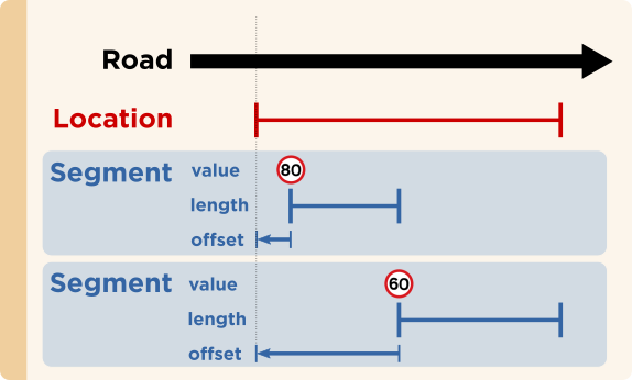 Figure 1: Relation between location, segment, and offset.
The following table gives detailed information about the different messages used in the data structure.
| Protocol buffers message type | Description |
|---|---|
| The SpeedLimitsFeed object is the top-level message. It provides meta data and the speed restrictions themselves. |
| The MetaData message provides data shared by all speed limit messages. It contains the creation time, supplier information, and the country for which the content is created. |
| The SpeedLimitMessage assigns one or more speed restrictions to a location. |
| The Location message defines a reference stretch.
All |
| The SpeedLimitSequence message holds one or more |
| The SpeedLimitSegment represents a continuous, non-overlapping stretch inside the reference location, for which a specific speed restriction is applicable. This message consists of the following:
|
| The speed information type describes the type of traffic sign. Possible values are:
|
Location referencing
Geographical representation of the road segments is an important part of the payload. The location reference system used is OpenLR. Since OpenLR prevents interpretation differences, licensing costs, map dependencies, or version dependencies, TomTom recommends using OpenLR.
OpenLR example (here printed using C escape sequences):
1 location {2 openlr {3 encoding: OPENLR4 version: "3"5 bytes: "\013\004\334L$\335\270\013?\261\003\371!%\013\021"6 }7 }
OpenLR
OpenLR is a dynamic location referencing method that allows the referencing of any road on the complete digital map. Because of its flexibility, it is possible to describe traffic events on high-level and lower-level road classes. The method is available free of charge.
The service uses binary format version 3, as described in the OpenLR whitepaper. The whitepaper, Software Developer Kit, and open-source reference implementations are available for download from the OpenLR website. TomTom offers support for third parties to implement and test their own implementations.