Satellite Tile

Purpose
The Maps Raster Satellite Tile API endpoint provides satellite map data that is divided into gridded sections called tiles. Tiles are square images with a size of: 256 x 256 pixels. The tiles are available at 20 different zoom levels, ranging from 0 to 19. For zoom level 0, the entire earth is displayed on one single tile, while at zoom level 19, the world is divided into 238 tiles. See the: Zoom Levels and Tile Grid.
Data Source
Satellite imagery data comes from Maxar Satellite Imagery for all supported zoom levels. Most of the detailed imagery for urban areas was captured in or after 2021.
Tile image format
The Maps Raster Tile API Satellite service supports the jpg format.
Overlay
The overlay can be applied to the Maps Raster Satellite Tiles using Map Styles.
Tile Sizes
The following tiles size is currently supported:
- 256 x 256 pixels
Run this endpoint
You can easily run this and other endpoints. Go to the TomTom API Explorer page and follow the directions.
Request data
HTTPS method: GET
- Constants and parameters enclosed in curly brackets { } must be replaced with their values.
- Please see the following Request parameters section with the required and optional parameters tables for their values. The generic request format is as follows.
URL format
https://{baseURL}/map/{versionNumber}/tile/{layer}/{style}/{zoom}/{X}/{Y}.{format}?key={Your_API_Key}
curl command format
curl 'https://{baseURL}/map/{versionNumber}/tile/{layer}/{style}/{zoom}/{X}/{Y}.{format}?key={Your_API_Key}
Request parameters
These parameters are used in calls to generate all tile layers.
- Required parameters must be used or the call will fail.
- Parameters and values are case-sensitive.
- Optional parameters may be used.
Required parameters | |
|---|---|
Parameter | Description |
string | The base URL for calling TomTom services. Value: |
string | The version of the service to call. Value: The current version is |
string | Layer of the tile to be requested. Values:
|
string | Style of the tile to be requested. Values:
|
integer | Zoom level of the tile to be rendered. Value: |
integer | The x coordinate of the tile on a zoom grid. Value: 0..2 zoom -1 |
integer | The y coordinate of the tile on a zoom grid. Value: 0..2 zoom -1 |
string | The format of the response. Value: |
string | An API Key valid for the requested service. Value: Your valid |
Request headers
The following table lists HTTP request headers of particular interest to clients of the Maps Raster Tile API Satellite endpoint.
Optional headers | Description |
|---|---|
Contains the content encoding (usually a compression algorithm), that the client is able to understand. Value: | |
Contains an identifier for a specific version of resource. The server will send back the requested resource, with a 200 HTTP status code, only if it doesn't have an ETag matching the given one. Value: | |
Tracking-ID | Specifies an identifier for the request. It can be used to trace a call.
The value must match the regular expression
Value: |
Response data
The Maps Raster Tile API, for a single request, returns one square tile in jpg format.
Response examples
Example 1: Whole world at zoom = 0
Request (Zoom = | Response (Zoom = |
|---|---|
| 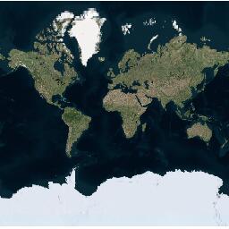 |
Example 2: Europe at zoom = 4
Request (Zoom = | Response (Zoom = |
|---|---|
| 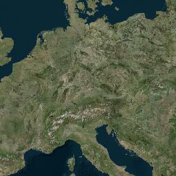 |
Example 3: Amsterdam at zoom = 17
Request (Zoom = | Response (Zoom = |
|---|---|
|  |
Error response
The Maps Raster Tile API Satellite service for an invalid request returns a response body in XML or JSON format. The XML format is returned by default. To have an error response returned in JSON format, application/json has to be specified in the Accept HTTP request header.
Error response field structure
Field | Description |
|---|---|
object | Main object of the error response. |
string | One of a server-defined set of error codes. |
string | A human-readable description of the error code. |
Error response example
1{2 "detailedError": {3 "code": "BAD_REQUEST",4 "message": "Invalid tile position arguments"5 }6}
1<errorResponse description="Invalid tile position arguments" errorCode="400">2 <code>BAD_REQUEST</code>3 <message>Invalid tile position arguments</message>4 </detailedError>5</errorResponse>
Response codes
Code | Meaning & possible causes |
|---|---|
| OK |
| Not Modified : The tile has not been modified. This code is
returned when the |
| Bad request : Probably malformed syntax.
|
| Forbidden :
|
| Too Many Requests : Too many requests were sent in a given amount of time for the supplied API Key. |
| Internal Server Error : There is a problem with the TomTom Maps Satellite Tile API service. |
| Service is currently unavailable. |
HTTP response headers
The following table lists HTTP response headers of particular interest to clients of the Maps Raster Tile API satellite endpoint.
Header | Description |
|---|---|
The Maps Raster Tile API allows cross-origin resource sharing (CORS). Value: | |
Contains directives for a caching mechanism. Value: | |
Indicates which encodings were applied to the response body. Value: | |
Contains information about the size of the response body. Value: | |
Indicates the media type of the resource returned. Value: | |
Contains the date and time at which the message was originated. Value: | |
Contains an identifier for a specific version of resource. Value: | |
Contains the date after which the response is considered outdated. Value: | |
Specifies the form of encoding used to safely transfer the response to the user. If this header is specified, Content-Length header will be absent. Value: | |
Tracking-ID | An identifier for the request. If the
Tracking-ID header was specified in
the request, it is replicated in the response. Otherwise, it is
automatically generated by the service. For details check
RFC 4122. |