Last-Mile Logistics: A Developer’s Point of View
)
Last-mile logistics refers to the transfer of a product or person from a hub to its final destination. In this article, we'll examine key aspects of last-mile fleet scenarios and how TomTom location services can help you build last-mile logistics applications.
In logistics and mobility businesses, many common mapping and routing challenges are related to the "last-mile." This refers to exactly what it sounds like: mapping and routing a delivery or transport service to its final destination.
Traditionally, last-mile logistics meant two kinds of fairly simple planning: either organizing static routes that delivery trucks run through every day, stopping for a precompiled list of package drop offs, or making individual trips to deliver things like meals or prescriptions.
What makes last-mile logistics complicated is that the highest concentration of last-mile deliveries occur in urban areas, where vans or other delivery vehicles have to deal with road restrictions, densely packed streets, limited parking, apartment buildings, unexpected traffic conditions, and so on. Even in suburban areas, traffic conditions can vary wildly between highly congested and free flowing on an hourly basis.
Recently, last-mile logistics has become much more dynamic. The growth of e-commerce use cases — from consumer goods to food delivery to ride-share services — means last-mile logistics has become much more fluid.
Since the last mile is based on the destination, it only becomes a known part of the equation when an order is placed. The fleet manager must deal with solving a much more complex problem than moving known goods from one point to many. They must be concerned with where the pickup is, the vehicle requirements, parking and delivery entrance locations — among many variables — to solve what has become a dynamic problem.
On top of that, customer expectations regarding estimated time of arrival (ETA) have changed drastically. Five years ago, you were happy to place an order and know “it will come on Saturday” or "in about 30 minutes." Today, in many areas, customers have learned to expect overnight deliveries of packages. For health and safety reasons, many families have turned to grocery and meal deliveries, and want to know within a few minutes when to expect delivery.
With much easier access to location technology and the ability to track drivers and packages in real time, ETAs can be accurate to within a minute. This raises customer expectations and fleet managers need to adjust their approach, taking this capability into account.
These use cases and customer expectations provide an opportunity for developers to create applications that reduce fleet costs, increase customer satisfaction, and meet compliance with committed service levels.
In this article, we cover the major components of last-mile logistics and the part that mapping and location management play. For example, what happens if you order lunch, or special order a book delivery?
Fleet Routing and Route Efficiency
In the more complex world of the delivery and on-demand environment we must consider routing fleet vehicles to the pickup point — say, a restaurant — then to a delivery point, and then perhaps to the next pickup or delivery point in the chain, and so on. It's a constantly fluid chain of next last-mile destinations.
Routing simply means finding the best path to a destination — a delivery address or rider pickup location. It's a simple solution we've all used to find directions to a destination. However, in a delivery scenario, you might have to generate routes for multiple deliveries, taking into account route efficiency and estimated time of arrival (ETA) to make sure deliveries arrive when expected.
For example, consider food delivery: time from the kitchen to the customer needs to be a consideration to ensure timely delivery of hot meals. ETA lets you tell the customer when to expect delivery, so they know when to break for lunch or listen for a knock at the door.
On the business planning side, another important routing consideration is how multiple stops can affect routing efficiency. For example, it’s more efficient if a food delivery service can make deliveries to several customers in a single trip.
Last-Mile Delivery and Accurate Geocoding
End locations — all the stops en route — are the destinations of last-mile logistics. These are generally fixed locations that need geocoding — translating descriptions or addresses into coordinates that can be mapped. Coordinates of delivery locations — or pickup locations in the realm of ridesharing — are crucial elements of accurate routing and route planning.
On-demand fleet applications need to provide the geocoded coordinates for the restaurants, the customer locations, and even the vehicles in the delivery fleet. For a third-party food delivery service, for example, these locations come in as order descriptions with customer delivery addresses. Geocoding services can automatically translate those customer addresses into map coordinates behind the scenes, creating automatic dispatching, routing, and delivery detail reports for drivers.
That's how the lunch to-go service takes your lunch order, knows where to deliver it, and can provide a clear, quick route to the driver. Geocoding for last-mile delivery can also provide additional information for accurate service including nearby landmarks, parking, and delivery entrance details.
Geofencing for Delivery Notifications
Another key capability for last-mile delivery applications is the ability to know when a delivery is about to happen. Location-aware applications can list delivery locations and route deliveries with estimated delivery times — also known as estimated time of arrival (ETA) — based on historical speed and traffic pattern data.
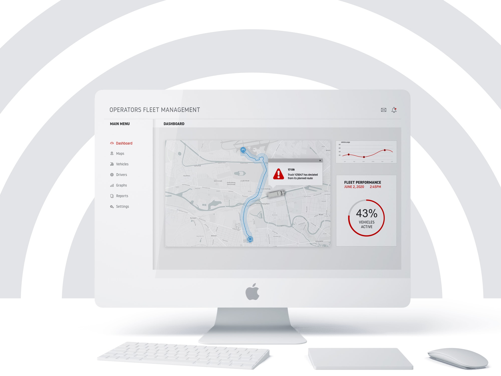
Knowing exactly when a delivery is nearing its destination is valuable information. It reflects the dynamic traffic conditions of an unpredictable world for confirmation of ETA. It gives fleet managers real-time updates of delivery progress and fleet position. It also enables applications to generate alerts and notifications that let the customer know dinner is almost here.
Geofencing means creating a virtual fence or boundary on a map — say for example, a boundary defining a neighborhood or a circle with a radius of 1 kilometer from a delivery destination. Geofencing technology enables applications to then fire events related to tracked objects entering or leaving a geofenced area.
A common application of geofencing is creating a fence around a destination — say 1 to 5 miles around a warehouse or the destination for a pizza delivery. When the delivery vehicle crosses the fence, an app could send an alert to the warehouse to get ready staging forklifts for unloading, shortening vehicle turnaround time. Or it could send an alert to the hungry customer that the pizza is nearby and they should get ready to answer the door.
Another use case is fleet monitoring. Geofences limits the map area under consideration, turning hundreds of individual fleet vehicle or delivery locations into insights for the business like if any vehicle in the fleet are in an unsafe situation (deviated from route or entered a restricted area) or to see how many vehicles are servicing a specific area.
Tools for Last-Mile Application Development
To create last-mile logistics applications for parcel delivery, you'll need understand and use these services:
Map display to create engaging application interfaces
Search and geocoding to find coordinates of delivery locations
Routing (including traffic and ETAs) for efficient transit times and for calculating the optimal route
Vehicle tracking to keep an eye on your fleet
Geofencing for alerts, notifications, and business insights
TomTom provides easy-to-use APIs that let software developers incorporate these services into effective fleet management applications for on-demand businesses. Let's look at some of the technologies you can use to quickly build sophisticated apps.
Maps may seem simple, but the effort involved in creating and maintaining a map is not. An effective map service like the TomTom Map Display API and Maps SDKs for Web, Android, and iOS make it easy to display maps in your application. With a few lines of code you can have a clear, interactive map that includes customizable styling, markers, routes, and the ability to add your own data overlays.
The TomTom Search API provides services for location search, geocoding, reverse geocoding, and more, including features targeted for electric vehicle (EV) fleets.
Search gives the user the ability to find a desination. Users can search the data underlying the geocodes to discover information including entrance location and hours of business.
[]Routing APIs take into account not only the directions for getting to a location, they also allow you to control for variables such as time, traffic congestion, and tolls. For accuracy, routing services need to provide up-to-date data. For example, routing services provide the ETA information necessary when you have to incorporate service levels into your applications. The TomTom Routing API provides capabilities for advanced routing with options for vehicle, cargo, and road types — which might be useful for cases routing larger vehicles or hazardous loads.
Because on-demand and parcel delivery businesses often want to operate as nimbly as possible, real-time intelligence about current fleet positions helps every next step in the process: routing and rerouting vehicles to provide efficient service. Vehicle tracking can also help with driver safety, by revealing whether a driver was exceeding the speed limit or changing lanes erratically.
Vehicle tracking has uses in both real-time and analytics applications. Developers can use the TomTom Location History services to capture and report fleet vehicle locations over time, providing the basis for business analysis and fleet planning applications.
The TomTom Geofencing API lets you create geofences for use with other services such as routing, location history, or generating alerts and notifications with the Notifications API.
Each of these functions lets application developers embed mapping functionality into their applications and improve last-mile logistics effectiveness.
Wrapping Up
As you've seen here, "last-mile logistics" has always been parts of the logistics equation — it's just getting packages, groceries, meals, or any other delivery to its destination.
With the increase in the number of companies offering delivery services, from one-day-fulfillment to grocery delivery to ride services, the ability to optimize costs, increase customer satisfaction, and meet compliance with committed service levels is important to business success.
TomTom provides APIs that connect application developers to the services they need to tackle all the details of last-mile delivery efficiency in real time — from routing that takes into account speed and traffic, to accurate ETAs, to notifications, to details like entrance location.
Next time you order a lunch delivery, consider all of the last-mile delivery technologies we've discussed that make it possible to get from order to hot meal — from geocoding your address, to giving the driver an efficient route, to getting your lunch hot and on time.
For more information, visit https://developer.tomtom.com/ and register for your free access.
To read more about TomTom solutions for fleet management, check out this related article: Using TomTom Location Services to Develop Fleet Logistics Applications.
Happy mapping!