Vector Tile Structure
Purpose
Vector Tiles are served in binary format, which uses Google Protocol Buffers as the method of serializing structured data. The serializing algorithm is very effective and as a result Vector Tiles are light-weight.
Vector Tile structure
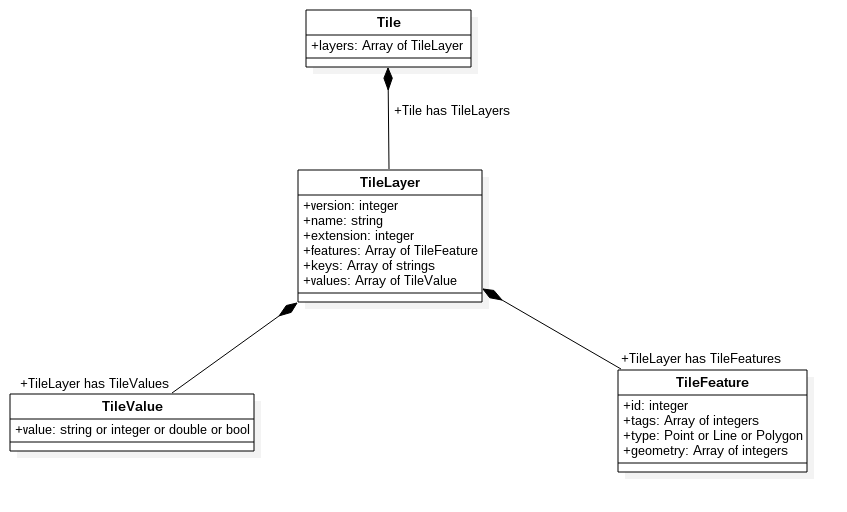
Vector Tile diagram
The following diagram shows dependencies between the properties of vector tile.
Legend
TileRepresents a vector tile as a whole entity. It consists of at least one
TileLayer.
If the tile does not contain any relevant data, it contains one layer namedempty.TileLayerPart of a
Tile, representing one of the layers that can be rendered later. In the Traffic API it can represent all of the traffic flow or all of the traffic incidents.Every
TileLayercontains the following fields:nameversionextent
It may also contain the following fields:
keysare an array of uniquestrings.valuesare an array of uniqueTileValues.featuresare an array of uniqueTileFeatures.
Arrays of
keysandvaluescontain the mapping for tags ofTileFeature.TileFeatureMember of an array of
featuresstored in aTileLayer, containing a geometry representation that can be rendered.It always contains the following fields:
typeis a type of geometry. It can bepoint,linestring, orpolygon.geometryis an array of encoded geometry that can be used for rendering. See the Decoding tile geometry section for details.
It may also contain the following fields:
tagsare an array containing properties of feature.They are a
TileFeature'sdetailed description which can be used for styling and later rendering the geometry.- They are encoded into an array of integers.
In order to decode them, the arrays of
keysandvalues, from correspondingTileLayermust be used.See the Decoding tile tags section for details.
TileValueEncoded representation of a string, integer, floating point, or boolean value.
It is stored in a
valuesarray, in aTileLayer.It is used for decoding
tagsof aTileFeature(together with the members of akeysarray).See the Decoding tile tags section for details.
Schema data
Formally, the structure of Vector Tile is described by the protocol buffer schema. It allows the generation of C++, Java, Python, Go, Ruby, Objective-C, and C# code based on proto file.
1package vector_tile23option optimize_for = SPEED;45message Tile {67 enum GeomType {8 UNKNOWN = 0;9 POINT = 1;10 LINESTRING = 2;11 POLYGON = 3;12 }1314 message Value {15 optional string string_value = 1;16 optional float float_value = 2;17 optional double double_value = 3;18 optional int64 int_value = 4;19 optional uint64 uint_value = 5;20 optional sint64 sint_value = 6;21 optional bool bool_value = 7;22 extensions 8 to max;23 }2425 message Feature {26 optional uint64 id = 1 [ default = 0 ];27 repeated uint32 tags = 2 [ packed = true ];28 optional GeomType type = 3 [ default = UNKNOWN ];29 repeated uint32 geometry = 4 [ packed = true ];30 optional bytes raster = 5;31 }3233 message Layer {34 required uint32 version = 15 [ default = 1 ];35 required string name = 1;36 repeated Feature features = 2;37 repeated string keys = 3;38 repeated Value values = 4;39 optional uint32 extent = 5 [ default = 4096 ];4041 extensions 16 to max;42 }4344 repeated Layer layers = 3;4546 extensions 16 to 8191;47}
Decoding Vector Tile
Decoding tile geometry
Vector Tile geometry uses the following coordinate system:
- Coordinates are always integers.
- The
(0,0)point is located in the upper-left corner of the tile. - The X axis has positive values to the right of the tile.
- The Y axis has positive values to the bottom of the tile.
- The tile may have margin, which is a buffer around the tile in the shape of a square frame.
- In the Traffic API, the size of the margin is by default equal to
0.1of the width/length of the tile. - The extent is equal to
4096, so the value range for X and Y coordinates is from0to4095. - If the tile has a margin, the coordinates values range is additionally extended with its value in both directions. This may cause coordinate values for points in the left or upper margin to be negative.
Vector Tile geometry is encoded as an array of 32 bit unsigned integers in the geometry field, belonging to the TileFeature.
Encoded format has the following structure:
[command_and_count][x0][y0]..[xn][yn][command_and_count][x0][y0]..
command_and_countcontains encoded values ofcommandandcount.[x0][y0]..[xn][yn]are encoded coordinate(x,y)pairs.
Command
The value of command is decoded as follows:
command = command_and_count & 0x7
- It can be interpreted as "paint brush movement" during rendering, in relation to point
(0.0)and previous commands. - In the first
TileFeaturecommand"paint brush" starts at point(0,0).
Command types
Command | Value | Coordinates | Description |
|---|---|---|---|
|
|
|
|
|
|
|
|
|
| none |
|
Count
The value of count is decoded as follows:
count = command_and_count >> 0x3
- It defines the
nnumber of[xn][yn]encoded coordinate pairs following thecommand_and_countvalue. - These coordinate pairs must be interpreted according to the preceding
commandtype.
Coordinates
Coordinates [x0][y0]..[xn][yn] are encoded in zigzag encoding and are relative to the previous coordinate pair and previous commands. This means that only the first coordinate pair [x0][y0] in first command in every TileFeature stores absolute values.
The coordinates are decoded as follows:
1decode(x0) = ((x0 >> 0x1) ^ (-(x0 & 0x1)))2decode(y0) = ((y0 >> 0x1) ^ (-(y0 & 0x1)))34decode(x1) = decode(x0) + ((x1 >> 0x1) ^ (-(x1 & 0x1)))5decode(y1) = decode(y0) + ((y1 >> 0x1) ^ (-(y1 & 0x1)))67...89decode(xn) = decode(xn-1) + ((xn >> 0x1) ^ (-(xn & 0x1)))10decode(yn) = decode(yn-1) + ((yn >> 0x1) ^ (-(yn & 0x1)))
1input :2layer : 0 :3 feature : 0 :4 type : POINT5 geometry : [9, 1136, 6564]67processing :8 geometry :9 command_and_count = 91011 command = 9 & 0x7 = 112 count = 9 >> 0x3 = 11314 x0 = 1136, y0 = 656415 decode(x0) = ((1136 >> 0x1) ^ (-(1136 & 0x1))) = 56816 decode(y0) = ((6564 >> 0x1) ^ (-(6564 & 0x1))) = 32821718output :19layer : 0 :20 feature : 021 geometry : POINT(561, 3282)
Decoding tile tags
In order to reduce tile size, the properties of each feature are encoded in a tags array.
- The
tagsarray contains integer values which are indexes ofkeysandvaluesarrays belonging to the corresponding layer. - The size of a
tagsarray is always even. - The content of a
tagsarray can be grouped into a list of pairs. Each odd element of an array is the first element of a pair, and each even element of an array is the second element of a pair. - The first element of each pair should be mapped to a
keysarray. - The second element of each pair should be mapped to a
valuesarray. - As a result, we get a decoded list of
tagswhere the first element is the tag name and the second element is the tag value in the form ofTileValue.
1input :2layer : 0 :3 "keys" : ["road_type", "traffic_road_coverage"],4 "values" : ["Motorway", "full"]5 feature : 0 :6 "tags" : [0,0,1,1]78output :9layer : 0 :10 feature : 0 :11 properties :12 "road_type" : "Motorway"13 "traffic_road_coverage" : "full"