Introduction
Start for free
Register now to use this API under our Freemium plan and begin with free API requests.
What is TomTom's Map Display API?
The Map Display API is a suite of web services designed for developers to create web and mobile applications around mapping. These web services can be used via RESTful APIs.
The offering includes:
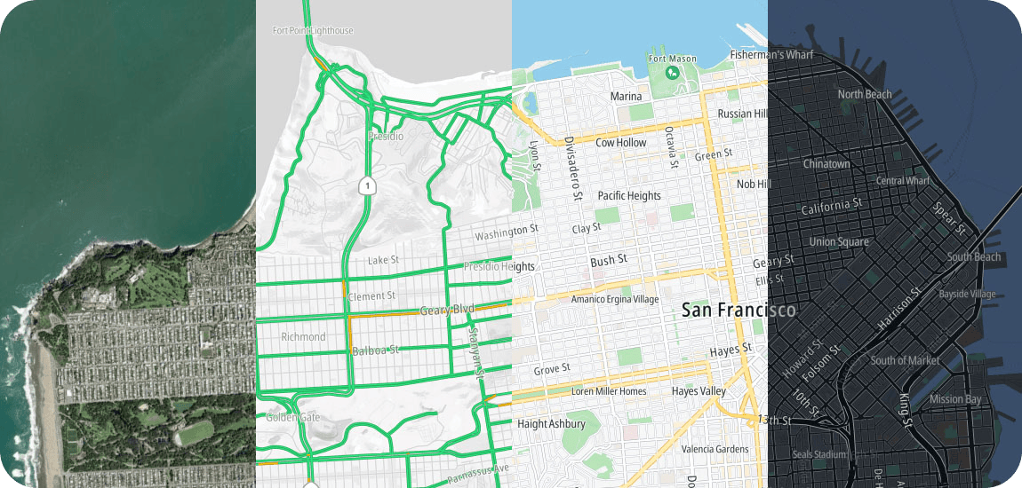
- Raster: Raster provides map images of the TomTom high-quality world map in raster graphics formats (png or jpg).
- Map images are tiles available in 23 zoom levels.
- Satellite images are tiles available in 20 zoom levels.
- Hillshade images are tiles available in 14 zoom levels.
- You can use the images provided in the Map Display API Raster Tile endpoint response to display maps in your own web or mobile application.
- Vector: Vector provides map images in vector format.
- You can use the images provided in the Map Display API Vector Tile endpoint response combined with your own custom style to draw them as you like.
- Vector tiles are fully customizable on the client side: you can switch on/off single layers or change style without sending another request.
For detailed geographic coverage information, please see TomTom's Map Display API Market Coverage page. The Map Display API consists of the following services with their endpoints:
Raster
The Map Display API Raster web service suite offers the following: Tile, Satellite, Hillshade, WMS, WMTS, Static Image, and Copyrights.
Vector
The Map Display API Vector web service suite offers the following: Tile and Content
Map Styles
The Map Display API Map Styles web service delivers resources required to display vector maps.
Map Maker
The TomTom map editor with simple and advanced styling capabilities empowers you to create the map you need, perfectly fitting your unique brand and use case.
Zoom Levels and Tile Grid
TomTom Maps use the Spherical Mercator projection coordinate system (EPSG:3857).
Copyrights
The Copyrights API is designed to serve copyright information for the Map Display services.
Map Display API Release Notes
Records the release date with the addition, improvement, deprecation, removal, and known issues associated with a product release.
Map Display API Market Coverage
Indicates where in the world the Map Display API is covered.
Getting started
Use the following topics to become more acquainted with this API and its endpoints.
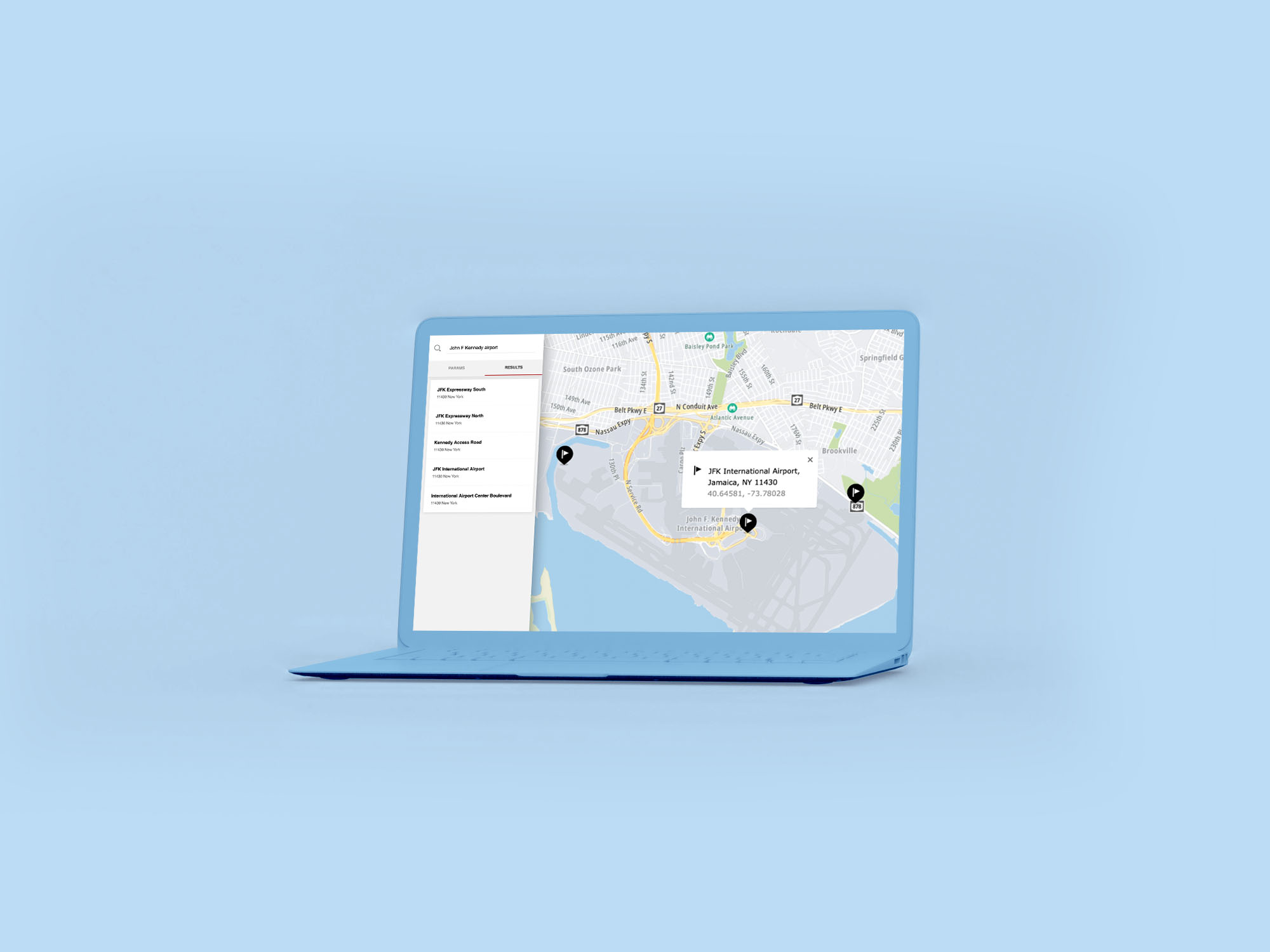
How to get a TomTom API Key
When you use our location Service APIs, we need a way to identify that it is your application that is making the request to use the service (API).

TomTom Knowledge Base
The TomTom Knowledge Base optimizes the retrieval of information via articles, blogs, FAQs, tutorials, and videos for your use and reference.

Map Display API Overview
This Overview page uses Frequently Asked Questions and provides answers regarding the TomTom Maps Display API.

Getting Started with the TomTom Maps APIs
A getting started instructional video.
Common use cases you can implement
Display a map
- Of the whole world with zooming and panning.
- Of a specific country.
- At the given location, and show its detailed surroundings.
Raster API
The Maps Raster API renders map data that is divided into gridded sections called tiles.
- Map tiles are square images (png or jpg format) in various sizes which are available at 23 different zoom levels, ranging from 0 to 22.
- Satellite tiles are square images (jpg only format) with a size of: 256 x 256 pixels and are available at 20 different zoom levels, ranging from 0 to 19.
- Hillshade tiles are square images (png only format) with a size of: 514 x 514 pixels and are available at 14 different zoom levels, ranging from 0 to 13.
- For zoom level 0, the entire earth is displayed on one single tile, while at zoom level 22, the world is divided into 244 tiles.
Raster features
- Attractive raster street map images.
- Satellite map images.
- Map tiles are pre-rendered at 23 zoom levels, ranging from one global tile down to 9.5m x 9.5m detailed map images.
- Satellite tiles are available at 20 zoom levels, ranging from one global tile down to 76m x 76m detailed map images.
- Hillshade map images.
- Each image corresponds with a position on an established zoom level grid system used by the WMS-C standard.
- Multiple shields per road.
- Country-specific shields for all covered regions.
- Toll roads marking.
Vector API
Similar to the Maps Raster API, the Maps Vector API serves data on different zoom levels ranging from 0 to 22. For zoom level 0, the entire earth is displayed on one single tile, while at zoom level 22, the world is divided into 244 tiles. The Maps Vector Service delivers geographic map data packaged in a vector representation of squared sections called vector tiles.
- Each tile includes pre-defined collections of map features (points, lines, road shapes, water polygons, building footprints, etc.) delivered in one of the specified vector formats.
- The format of the tile is formally described using the protobuf schema.
Vector features
- Attractive vector street map images.
- Served at 23 zoom levels, ranging from one global tile down to 9.5m x 9.5m detailed map images.
- Each image corresponds with a position on an established zoom level grid system used by the WMS-C standard.
- Toll roads marking.
- All labels in country national languages.